 ProMapRanker
Best Deer Hunting Apps in 2026


Multi-state mapping and offline use · Pricing starts at: $34.99 per year
Key takeaways
- onX Hunt remains the mapping standard for multi-state hunters, with deep layers and offline maps on paid plans.
- HuntWise is the best value for whitetail hunters who want weather-driven movement forecasts alongside maps.
- HuntStand gives a genuinely useful free tier, while CoHunt is the cheapest full-featured option at $24.99 per year.
- BaseMap suits hilly ground where terrain reading matters, and Spartan Forge adds deer movement prediction.
- Always confirm a boundary and land permission yourself, and download offline maps before you leave signal behind.
Quick comparison
| Pick | Great for | Pricing starts at | Free tier | |
|---|---|---|---|---|
| onX Hunt | Multi-state mapping and offline use | $34.99 per year | Free trial (7 days) | Visit |
 HuntWise | Whitetail forecasts and free maps | Free | Yes | Visit |
 HuntStand | Free tier and group hunt planning | Free | Yes | Visit |
 BaseMap | Terrain reading on hilly ground | $39.99 per year | Free trial | Visit |
 Spartan Forge | Deer movement prediction | See website | Free trial | Visit |
 GoHunt | Draw odds and western big game research | See website | No | Visit |
 CoHunt | Low-cost full mapping with offline chat | $24.99 per year | No | Visit |
 Infinite Outdoors | Booking vetted private land hunts | Free | Yes | Visit |
 LandTrust | Booking private land access | Free | Yes | Visit |
The best deer hunting apps
A deer hunting app is mainly a map with a memory. It shows where you are, whose land you are on, where you have seen deer, and what the weather may do next. The best pick depends on how many states you hunt, how far you go from cell signal, and how much you want weather prediction versus pure mapping. This guide covers legal hunting only. Hunters must follow state seasons, licences and land rules, check the state wildlife agency before every trip, and never trespass, since an app boundary line is a guide, not a legal survey.
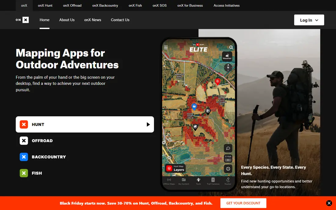
onX Hunt is the app most hunters already know, and its strength is mapping depth. Property lines, landowner names, terrain layers, satellite imagery and custom mapping tools sit in one place, and paid plans let you download maps for offline use. Elite covers all 50 states and Canada, which suits hunters who travel for deer season.
Pricing checked in October 2026 listed Premium at $34.99 per year for one state, Two-State at $49.99, and Elite at $99.99 per year, with a 7-day free trial. There is no true free tier, so budget hunters should start with HuntStand or HuntWise free tiers first. If you hunt several states and want the deepest maps, onX is still our pick.
- Property lines for all 50 states on Elite
- Offline maps
- Trail camera sync on Elite
- No true free tier
- Best features sit on the Elite plan

HuntWise builds around HuntCast, a daily score that blends wind, pressure, temperature, moon phase and past movement for your spot and species. That forecast helps whitetail hunters pick a stand on a given morning, rather than guessing from wind alone. The free tier includes full US mapping, which is generous by this list's standards.
Pro costs $59.99 per year and Elite $119.99 per year in October 2026 checks, adding nationwide property lines and landowner lookup. HuntWise is less strong for backcountry terrain work than onX, and it has no live team location sharing in the way some hunters expect. For eastern and midwestern deer hunters, the forecast plus free maps make it hard to beat.
- HuntCast movement forecasts
- Free tier with full US mapping
- Shared hunt areas and pins
- Live location sharing is limited
- Top tier costs $119.99 per year
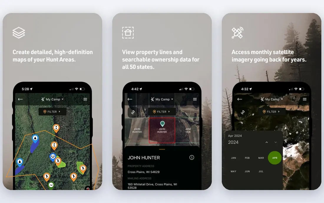
HuntStand is the sensible starting point if you want to try a hunting app without paying first. The free tier is genuinely usable for basic mapping and marking, and paid tiers add property lines, landowner data, offline maps and trail camera tools. Group features help a lease or a camp share pins and plans.
Pro runs about $34.99 per year and Ultimate about $99.99 per year in October 2026 checks. The catch is that the features most hunters actually want, offline maps and landowner lookup, sit behind paywalls, so the free tier is a trial of the idea rather than the full tool. Still, for private land and lease hunting, HuntStand is strong value.
- Usable free tier
- Property lines on paid tiers
- Trail camera photo logging
- Offline maps and landowner data need paid tiers
- Top tier costs $99.99 per year
BaseMap leans into terrain. Its 3D views and elevation modelling make ridges, benches and saddles easier to read than a flat satellite image, which matters on hilly or mountainous deer ground. Property boundaries cover the US, and offline maps are available on paid plans, so it works as a field map as well as a scouting tool.
Pricing in October 2026 checks ran from about $39.99 to $99.99 per year depending on tier, so confirm the current tier on the vendor site. Trail camera integration lags HuntStand and onX, and sharing features are less polished. On flat farm ground, that terrain edge matters less, so treat BaseMap as a specialty pick for hill country.
- Strong 3D terrain and elevation views
- US property boundaries
- Offline maps
- Trail camera integration is basic
- Multi-user sharing is still catching up
Spartan Forge pairs mapping with deer movement prediction, aiming to tell you not just where deer live, but when they are likely to move. Its layers and scouting tools support stand placement and route planning, and it has built a loyal following among serious whitetail hunters who plan around forecasts.
The main drawback is transparency: pricing is less plainly published than onX or HuntWise, so use the free trial and confirm the cost before committing. It also lacks the huge user base and camera ecosystem of onX. If prediction matters more to you than camera sync, Spartan Forge deserves a trial week.
- Deer movement forecasting
- Detailed mapping layers
- Scouting tools
- Pricing is not published as plainly as rivals
- Smaller community than onX
GoHunt is built for hunters who chase tags, not just deer on familiar ground. Its draw odds research and unit filtering help western hunters decide where to apply, which units are realistic, and how points stack up over years. Mapping sits alongside that research, so planning and applying stay in one account.
That western focus is also its limit for this list: a hunter who only hunts whitetail on private land in one eastern state will get less from GoHunt than from HuntWise or HuntStand. Pricing is quote and membership based, so check the vendor site for the current plan. For multi-state western deer and elk hunters, it is a serious tool.
- Draw odds research
- Unit filtering
- Mapping and gear shop in one account
- Priced for western hunters, less useful for eastern whitetail only
- No free tier of note
CoHunt is the value surprise in this list: one plan at $24.99 per year includes every feature, including property boundaries for all 50 states. It also offers offline communication options for hunting parties beyond cell signal, including Bluetooth and radio-linked messaging, which is a real field advantage in remote ground.
There is no desktop planner yet, and Canada is not covered, so Canadian hunters should keep onX alongside it. As a newer app, its camera and community ecosystem is smaller. For US deer hunters who want full mapping at the lowest annual price here, CoHunt is our budget pick.
- One $24.99 plan with all features
- Property lines for all 50 states
- Offline messaging options
- No desktop planner
- No Canada coverage
- Newer and smaller than onX
Infinite Outdoors solves a different problem: access, not just mapping. Hunters can browse vetted private properties and book hunts directly, with free public and private land layers and 3D mapping for scouting. That booking route suits hunters without a lease, a camp or family land to fall back on.
The free tier covers browsing and basic layers, while Access+ membership costs $49.99 per year in October 2026 checks, and booking fees sit on top. Availability depends entirely on listings near you, so check your area before paying. If access is your bottleneck, this app is worth more than another map.
- Vetted private properties to book
- Free land layers
- 3D mapping and scouting tools
- Booking costs sit on top of membership
- Access depends on listings near you
LandTrust is a marketplace for private land access, with a large acreage listing across many US states. Hunters can browse landowner listings for hunts and other outdoor activities, then book access directly, which suits hunters without a lease or family land. That marketplace model gives more choice than a single-property booking app.
There is currently no mobile app, so browsing and booking happen on the web, which is a drawback in the field. Booking costs sit on top of free browsing, and availability depends on listings near you. If access is your main problem and you want the widest choice, LandTrust is worth checking before you pay for another map.
- Large marketplace of private land access
- Hunts and outdoor activities
- Landowner listings
- No mobile app currently
- Booking costs sit on top of browsing
How we picked these
We compared official pricing pages, vendor feature lists and October 2026 comparison checks, and we kept only apps that are live, cover US deer hunting, and offer maps, forecasting or access tools that a deer hunter can actually use in the field. We weighed map depth, offline use, price, free tier strength and prediction tools, and we left out apps that had shut down, covered only fishing or hiking, or gave no clear deer hunting use.
How to choose a deer hunting app
Start with where you hunt. One state on private land needs far less than five states on public ground, so a single-state onX plan or a free HuntWise tier may be enough, while multi-state hunters get more from Elite or CoHunt. Check whether your ground has cell signal: if it does not, offline maps are not optional, and you should download them at home before the trip.
Next, decide what extra help you want. Weather-driven forecasts suit whitetail hunters picking a stand each morning, terrain tools suit hill country, and camera sync suits hunters running several cameras. Do not pay for all three if you only use one. Use free tiers and trials for a full weekend before subscribing, and confirm that parcel data matches what you see on the ground.
Finally, treat every boundary line as a starting point, not proof. County records lag behind sales, fences move, and posted signs matter more than a screen. Confirm permission in writing for private land, check season dates and licence rules with your state wildlife agency, and carry a paper map or a second device as backup.
Frequently asked questions
What is the best deer hunting app overall?
For most multi-state hunters, onX Hunt is the standard for map depth and offline use. For whitetail hunters who want forecasts and a free start, HuntWise is close behind, and CoHunt is the cheapest full-featured option at $24.99 per year.
What is the best free hunting app?
HuntWise has the strongest free tier here, with full US mapping at no cost. HuntStand also has a genuinely usable free tier for basic mapping and marking, while onX has no true free tier and relies on a 7-day trial.
What is the best GPS app for hunting?
onX Hunt, HuntWise, HuntStand and BaseMap all work as GPS hunting apps with offline maps on paid plans. onX has the deepest layers, BaseMap reads terrain best on hilly ground, and CoHunt adds offline party messaging beyond cell signal.
Can a hunting app tell me where I can legally hunt?
No app can give a legal answer on its own. Apps show parcel and public land layers, but seasons, licences, weapon rules and access permission come from your state wildlife agency and the landowner. Always confirm both before you hunt.
Do I need cell signal for a deer hunting app?
Not if you download offline maps first. onX, HuntStand, BaseMap and CoHunt all support offline maps on paid plans. Download your hunt area at home, test it in airplane mode, and carry a backup map in case your phone fails.
Sources
See where you really rank - block by block
ProMapRanker scans Google Maps across a grid of your service area. Simple monthly plans from $19, white-label on every plan.
Start freeKeep reading
 zscaler alternatives
Best Zscaler Alternatives in 2026
Looking for zscaler alternatives? We compare 9 SASE and zero trust platforms on architecture, data protection, pricing, and fit for your network and team.
Read → zapier alternatives free
Best Zapier Alternatives Free in 2026
Nine automation tools for zapier alternatives free in 2026, all with genuinely free tiers, plus free plan limits, starting prices and upgrade paths explained.
Read → which platform is best for online reputation
Which Platform Is Best for Online Reputation in 2026
Wondering which platform is best for online reputation? We compare 8 review, listing, and response tools for small and multi-location businesses and agencies.
Read →